I'm not going to link all the sets individually, as there's about 11 new sets encompassing the remainder of Nathan and Justin's visit to Ireland, our time in Scotland, the Salthill Airshow, and my road trip to Dublin and Northern Ireland last week.
There are some really cool shots in there, IMHO, particularly the Isle of Skye set and the Road Trip Part II set, so it's work a look:
Flickr Me!
Showing posts with label photos. Show all posts
Showing posts with label photos. Show all posts
Monday, July 2, 2007


Tuesday, June 12, 2007
Two more victims fall to the awe of stone fences and towering cliffs
Successfully met up with Justin and Nathan this morning. I took the bus down to Shannon to meet them after giving up any hope of being able to give them directions to navigate through Galway to my place. Besides, I figured if they got any sleep at all and would be up for a couple hours of sight-seeing, we could hit the Cliffs of Moher and the Burren on the way back up to Galway, saving some time later in the week.
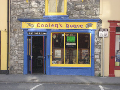
First stop though, since we were roughly in the area, was Ennistimon, and I bought them their first round of Guinness at Cooley's House. The place was surprisingly busy for 11 in the morning.
Coming out of town, we missed a turn and ended up taking about a 30-40 minute detour down through Miltown Malbay "on our way" to Lahinch, but it gave them a good chance to see what passes for "roads" in northern County Clare were like, along with the rolling farmlands they crossed.
We eventually got back on track and stopped off at the Cliffs of Moher. I remember being surprised at how much more developed the cliffs were as a tourist destination two years ago, versus my first visit there in '94. Well, the development has continued since then, with a large car park (parking lot) across the road. Eight euros it costs now to park a car and wander, with a very nice, well-polished visitor center (an Atlantic Edge exhibit can be taken in for an additional 4 euro per head. We passed on that.) and a covey of little shops dug into the hillside leading up to the cliffs.
Passing a woman on the walkway doing a poor job of playing a concertina, it struck me that had I brought my whistle and wore something other than a U-M T-shirt, I could've sat there and played some tunes, and in the time that Justin and Nathan were exploring the cliffs, have made enough to have covered our parking fee. Hindsight.
Oh, one more thing of note from the Cliffs... I think I can cross one more thing off my list: seeing a puffin. Maybe. To be honest, I have no idea whether the tons of tiny black dots covering Goat Island at the base of the cliffs were puffins or not, but a sign there indicated that they could be seen there today, so I'm guessing they were. Not a very satisfying mark off the list, but a mark nonetheless.
After the cliffs, we headed to Doolin to grab an extremely overpriced lunch at Gus O'Connor's. Sadly, I think Conal's assessment of Doolin is pretty right on. What was once a tiny, quaint, quasi-town and wonderful hub of traditional music has become little more than a glorified tourist trap. Sad.
From Doolin, we made our way north again, through Lisdoonvarna, Kilfenora, and up across The Burren. We stopped off to walk up and take a close look at the Poulnabrone Dolmen, which while I had driven past and admired from the road several times, I'd never ventured up close to. It's yet another site that has been ridiculously over-developed since the first time I saw it, but at least they're not charging admission...yet.
On the road again and just past Kinvarra, we stopped again to have a quick look at Dunguaire Castle. Apparently, like at Bunratty Castle near Shannon, they hold a medieval feast. Had we known in advance, it might've been a fun thing to do, as it was nearing dinner time by the time we got there, and the doors were closed in preparation. We walked the grounds a bit though before getting back on the road and finally getting back into Galway.
It turned out to be a fairly full day for a first day in, as we got back to Galway around 6 o'clock. Justin's taking a nap right now, Nathan, "The Iron Man" just went for a run and is gonna hop in the shower. I'm going to run and pick up an air mattress that I'm borrowing from a friend so that we all have a place to sleep and then going to run to Dunnes to get stuff for breakfast in the morning.
After that, a little dinner, some drinks and a session at the Crane, and we'll call it a night whenever those guys are ready to crash.
Tomorrow will be a pretty full day of touring Connemara and knocking around Galway some more, plus at some point, I need to pack for Scotland.
So, updates may be somewhat sporadic from this point on, but I'll check in when I can.
Photos of Day 1 of Justin and Nathan's visit.
First stop though, since we were roughly in the area, was Ennistimon, and I bought them their first round of Guinness at Cooley's House. The place was surprisingly busy for 11 in the morning.
Coming out of town, we missed a turn and ended up taking about a 30-40 minute detour down through Miltown Malbay "on our way" to Lahinch, but it gave them a good chance to see what passes for "roads" in northern County Clare were like, along with the rolling farmlands they crossed.
We eventually got back on track and stopped off at the Cliffs of Moher. I remember being surprised at how much more developed the cliffs were as a tourist destination two years ago, versus my first visit there in '94. Well, the development has continued since then, with a large car park (parking lot) across the road. Eight euros it costs now to park a car and wander, with a very nice, well-polished visitor center (an Atlantic Edge exhibit can be taken in for an additional 4 euro per head. We passed on that.) and a covey of little shops dug into the hillside leading up to the cliffs.
Passing a woman on the walkway doing a poor job of playing a concertina, it struck me that had I brought my whistle and wore something other than a U-M T-shirt, I could've sat there and played some tunes, and in the time that Justin and Nathan were exploring the cliffs, have made enough to have covered our parking fee. Hindsight.
Oh, one more thing of note from the Cliffs... I think I can cross one more thing off my list: seeing a puffin. Maybe. To be honest, I have no idea whether the tons of tiny black dots covering Goat Island at the base of the cliffs were puffins or not, but a sign there indicated that they could be seen there today, so I'm guessing they were. Not a very satisfying mark off the list, but a mark nonetheless.
After the cliffs, we headed to Doolin to grab an extremely overpriced lunch at Gus O'Connor's. Sadly, I think Conal's assessment of Doolin is pretty right on. What was once a tiny, quaint, quasi-town and wonderful hub of traditional music has become little more than a glorified tourist trap. Sad.
From Doolin, we made our way north again, through Lisdoonvarna, Kilfenora, and up across The Burren. We stopped off to walk up and take a close look at the Poulnabrone Dolmen, which while I had driven past and admired from the road several times, I'd never ventured up close to. It's yet another site that has been ridiculously over-developed since the first time I saw it, but at least they're not charging admission...yet.
On the road again and just past Kinvarra, we stopped again to have a quick look at Dunguaire Castle. Apparently, like at Bunratty Castle near Shannon, they hold a medieval feast. Had we known in advance, it might've been a fun thing to do, as it was nearing dinner time by the time we got there, and the doors were closed in preparation. We walked the grounds a bit though before getting back on the road and finally getting back into Galway.
It turned out to be a fairly full day for a first day in, as we got back to Galway around 6 o'clock. Justin's taking a nap right now, Nathan, "The Iron Man" just went for a run and is gonna hop in the shower. I'm going to run and pick up an air mattress that I'm borrowing from a friend so that we all have a place to sleep and then going to run to Dunnes to get stuff for breakfast in the morning.
After that, a little dinner, some drinks and a session at the Crane, and we'll call it a night whenever those guys are ready to crash.
Tomorrow will be a pretty full day of touring Connemara and knocking around Galway some more, plus at some point, I need to pack for Scotland.
So, updates may be somewhat sporadic from this point on, but I'll check in when I can.
Photos of Day 1 of Justin and Nathan's visit.
We've got highlights
Not as many as I'd intended, but YouTube is being frumpy with me right now.
It was a mixed day for the Faithful County faithful at O'Moore Park in Portlaoise yesterday. In the Leinster Senior Football Championship match, Offaly defeated an overmatched Carlow side by a score of 2-19 to 3-7. In the semi-final round of the Leinster Senior Hurling Championship, however, Kilkenny outclassed Offaly in the second half to finish with a 1-27 to 1-13 victory.
Translation please?
In both Hurling and Gaelic Football, the pitch (field) has a goal at either end, similar to a soccer goal, but with upright poles extending on the sides making an H with the crossbar across the top of the goal. Getting the ball into the net beneath the crossbar is called a "goal" and is worth three points, while getting the ball between the uprights over the crossbar is simply called a "point". The winner is determined by the highest total of points (number of points plus 3x the number of goals) but the scores are always represented in terms of goals-points.
To put this into American terms, you might say that Michigan defeated Notre Dame last year by a score of 6(6)-2 to 3(3)-0.
In the football match, Offaly scored 2 goals and 19 points for a total of 25 to Carlow's 3 goals and 7 points (16). The match was not nearly that close though. Carlow scored first, but the rest of the game belonged to Offaly, save for a late flurry of goals and points that came too little too late for Carlow.
Carlow attacking, but the point attempt goes wide left
The Hurling match was the feature event of the day, with Kilkenny being consistently among the best hurlers in the nation (Cork has a fine hurling tradition themselves, so I'm now fortunate enough to have seen two of the very best hurling counties in action, as I saw a Cork-Antrim match when I was there in 2005.). Offaly hurling had some strong years in the 80's and 90's, but has fallen on hard times now. I sense that the rivalry with Kilkenny is still a fierce one nonetheless.
Kilkenny were really brilliant. They were deadly in notching points from all over the field and took advantage of nearly every open shot. They jumped to a quick lead with 3 points in the opening minutes, but Offaly fought back and tied it shortly therafter. Another point a few minutes later, though, and Kilkenny would lead the remainder of the match.
Just before the intermission, though, came the highlight of the day. Offaly brought the match back to a 1-point margin with the first goal of the match on a free (penalty shot) making the half-time score 0-14 to 1-10 in favor of Kilkenny. I have a great video of this, but its one of the ones YouTube is not allowing for some reason. Instead, though, here is a clip of a point Offaly scored on a penalty shot earlier in the half:
The second half belonged to Kilkenny, though, as Offaly was able to manage but 3 points in the side. to Kilkenny's 1-13 making for a fairly lopsided final.
The atmosphere was fun and festive. The matches were played back-to-back and tickets (20 euro for general admission in the "stand"--covered seating--and 15 for standing room only in the "terrace") covered both matches. We got their early and opted to pop the extra 5 euro to be able to sit in the shade, vs. standing in the sun, and easily found a couple of seats right in the front row, close to midfield.
The venue, O'Moore Park in Portlaoise, County Laois, was about as geographical neutral as you can get, being centrally located amongst the three counties that were participating. Offaly fans seemed to be by far the most well represented, probably owing mainly to the fact that they were playing in both matches. Kilkenny and Carlow had plenty of support as well, though, with their black and gold striped jersies for Kilkenny and the green gold and red of Carlow being sprinkled around the pitch.
The attendance, per official reports on the matches was 11,490, which seemed to be about 80% capacity.
It took about 2 hours to drive there, but coming back, with plenty of daylight left, we opted for a scenic detour home and drove through the Slieve Bloom mountains on the Laois/Offaly border, also stopping off briefly at Redwood Castle near Portumna, and grabbing dinner at an Indian Restaurant in Birr, which apparently is joked as Ireland's coldest town (rather than it's drunkest town, if the name were pronounced the other logical way that it might be.).
For more photos of the match, as well as the drive home, Flickr it!
It was a mixed day for the Faithful County faithful at O'Moore Park in Portlaoise yesterday. In the Leinster Senior Football Championship match, Offaly defeated an overmatched Carlow side by a score of 2-19 to 3-7. In the semi-final round of the Leinster Senior Hurling Championship, however, Kilkenny outclassed Offaly in the second half to finish with a 1-27 to 1-13 victory.
Translation please?
In both Hurling and Gaelic Football, the pitch (field) has a goal at either end, similar to a soccer goal, but with upright poles extending on the sides making an H with the crossbar across the top of the goal. Getting the ball into the net beneath the crossbar is called a "goal" and is worth three points, while getting the ball between the uprights over the crossbar is simply called a "point". The winner is determined by the highest total of points (number of points plus 3x the number of goals) but the scores are always represented in terms of goals-points.
To put this into American terms, you might say that Michigan defeated Notre Dame last year by a score of 6(6)-2 to 3(3)-0.
In the football match, Offaly scored 2 goals and 19 points for a total of 25 to Carlow's 3 goals and 7 points (16). The match was not nearly that close though. Carlow scored first, but the rest of the game belonged to Offaly, save for a late flurry of goals and points that came too little too late for Carlow.
The Hurling match was the feature event of the day, with Kilkenny being consistently among the best hurlers in the nation (Cork has a fine hurling tradition themselves, so I'm now fortunate enough to have seen two of the very best hurling counties in action, as I saw a Cork-Antrim match when I was there in 2005.). Offaly hurling had some strong years in the 80's and 90's, but has fallen on hard times now. I sense that the rivalry with Kilkenny is still a fierce one nonetheless.
Kilkenny were really brilliant. They were deadly in notching points from all over the field and took advantage of nearly every open shot. They jumped to a quick lead with 3 points in the opening minutes, but Offaly fought back and tied it shortly therafter. Another point a few minutes later, though, and Kilkenny would lead the remainder of the match.
Just before the intermission, though, came the highlight of the day. Offaly brought the match back to a 1-point margin with the first goal of the match on a free (penalty shot) making the half-time score 0-14 to 1-10 in favor of Kilkenny. I have a great video of this, but its one of the ones YouTube is not allowing for some reason. Instead, though, here is a clip of a point Offaly scored on a penalty shot earlier in the half:
The second half belonged to Kilkenny, though, as Offaly was able to manage but 3 points in the side. to Kilkenny's 1-13 making for a fairly lopsided final.
The atmosphere was fun and festive. The matches were played back-to-back and tickets (20 euro for general admission in the "stand"--covered seating--and 15 for standing room only in the "terrace") covered both matches. We got their early and opted to pop the extra 5 euro to be able to sit in the shade, vs. standing in the sun, and easily found a couple of seats right in the front row, close to midfield.
The venue, O'Moore Park in Portlaoise, County Laois, was about as geographical neutral as you can get, being centrally located amongst the three counties that were participating. Offaly fans seemed to be by far the most well represented, probably owing mainly to the fact that they were playing in both matches. Kilkenny and Carlow had plenty of support as well, though, with their black and gold striped jersies for Kilkenny and the green gold and red of Carlow being sprinkled around the pitch.
The attendance, per official reports on the matches was 11,490, which seemed to be about 80% capacity.
It took about 2 hours to drive there, but coming back, with plenty of daylight left, we opted for a scenic detour home and drove through the Slieve Bloom mountains on the Laois/Offaly border, also stopping off briefly at Redwood Castle near Portumna, and grabbing dinner at an Indian Restaurant in Birr, which apparently is joked as Ireland's coldest town (rather than it's drunkest town, if the name were pronounced the other logical way that it might be.).
For more photos of the match, as well as the drive home, Flickr it!
Friday, June 8, 2007
There's only one pub on the whole island
That should give you an idea of how small, quaint and old-fashioned Inis Meain is.
It was fantastic. I got a ton of pics uploaded to Flickr, but am too tired right now to parse through highlights, so you're on your own to peruse the galleries:
Inis Meain - Day 1
Inis Meain - Day 2
But I will leave you with this. The playing's not perfect, and unfortunately, it cuts off just before the last phrase of the tune, but this was how I got to enjoy sunset yesterday:
It was fantastic. I got a ton of pics uploaded to Flickr, but am too tired right now to parse through highlights, so you're on your own to peruse the galleries:
Inis Meain - Day 1
Inis Meain - Day 2
But I will leave you with this. The playing's not perfect, and unfortunately, it cuts off just before the last phrase of the tune, but this was how I got to enjoy sunset yesterday:
Monday, June 4, 2007
Not much, just some more photos
I'm trying to get some short audio clips from around various sessions and street performers up to give you a taste of what Galway sounds like, but am having some tech difficulties. (If anyone happens to know of a good site that will host a small number or short .mp3s and allow remote linking to them for free, please let me know!)
In the meanwhile, here's a set of some more assorted shots I've taken around town over the last couple of days. I'm somewhat fascinated by the myriad of criss-crossing channels and canals that stretch across Galway and tried to capture that a bit here. I also spent some time yesterday walking around the campus of NUI Galway finally, and have a handful of pics from there, too:
"So do you like photos, man???"
In the meanwhile, here's a set of some more assorted shots I've taken around town over the last couple of days. I'm somewhat fascinated by the myriad of criss-crossing channels and canals that stretch across Galway and tried to capture that a bit here. I also spent some time yesterday walking around the campus of NUI Galway finally, and have a handful of pics from there, too:
"So do you like photos, man???"
Thursday, May 31, 2007
Mini-trip report: The Burren and northern Clare
Despite it only being a day-trip, I took enough photos to break them down into three separate galleries:
Apparently the first "mountain" I climbed is only a hill, called Abbey Hill. Still not too shabby, it's the right-most peak seen in this photo that I took on Monday evening from the park near Salthill:

Abbey Hill was a fairly easy climb. Mostly large, stable rock, at a gentle enough incline. At the top was a large stone pile and the intersection of several stone fences that cut the mountain like a pie. The peak of Abbey Hill can actually be seen in high res satellite images on Google Maps here.
 Lunar landscape on Abbey Hill
As I got near the top, I saw a man sitting on the peak, possibly wearing a hooded sweatshirt. He appeared to be sitting there, having a picnic with a bottle of wine next to him. As I got a bit closer, I realized the bottle of wine was in fact a person, and the man was the stone pile. By the time I reached the peak (I laid back and made my way to the large plateau area just below the peak to the north to give them time), whoever had been there was gone. I had the mountain to myself, it seemed and I lingered a good half hour or so, busting out my whistle to play a few tunes. After a while, a man and his young son came along. I left the summit to them and started making my way down.
When I got back to the car, I decided I'd play normal tourist a bit and find Ailwee Cave. Not a difficult challenge, what with large signs for it all over the region and all, but I'd heard good things about it--plus... it had just been featured in an episode of Father Ted that I'd seen the night before!
Ailwee Cave is not just a cave--it's a showcave. And it's not just any showcave. It's Ireland's Premier Showcave. Seriously, its pretty impressive. It's very much developed with a visitor center, gift shop, cafe, guided tours and the whole works. The cave itself runs for something like a mile into the mountain itself. Only part of it is open to the tour, for obvious reasons, but most of it was big enough to walk around in, with a few chambers that were several stories high, including this one with a waterfall:

Back in the parking lot, is the starting point for a mountain walk up Ailwee Mountain, in which the cave is set.
Ailwee Mountain was a much rougher hike than Abbey Hill. There were a lot of short, but steep terrace sections that often involved a little bit of climbing on all fours, at least for stabilization. Nothing like true rock-climbing that would require equipment or spotting or anything, but not a simple walk, either. On top of that, much of the terrain was covered with scrubby grass, which actually made for difficult walking. The grass was generally just a thin layer of growth over the rocks, which did nothing more than to hide the gaps and loose, smaller stones. It was on this terrain that I did take a few small spills, mostly on the way back down, twisting my ankle and scraping up my wrist and hand a bit on one.
On top of that, the mountain just seemed to keep going and going. Particularly near the top, it was actually relatively flat. Large, sloping fields were frustrating as I kept trying to find the very peak. I finally set my sights on a large rock pile that appeared and made it my goal to get to that. It was certainly a local peak, although the field appeared to continue to gradually climb up a bit to the north from there, there didn't seem to be much indication that it was going to be much higher.
It was from this point that I texted-in the post below, describing the fantastic view that was to be had, seen in the round, here:
After I made it down from Ailwee Mountain, I headed off to nearby Kilfenora, where I finally got to (re?-)meet Raeanne, and her husband Mike. Long-time readers will remember me mentioning Raeanne in several of the early posts, as she was very helpful in providing info and advice during the planning stages of this trip. She immigrated to Ireland from my own hometown several years ago after studying abroad here and meeting and marrying Mike. We chatted for a while about home and Ireland over a pint at Nagles Pub in downtown Kilfenora. Unfortunately, I had the camera in my pocket the entire time, but forgot about it until I was about a mile down the road. So, no pictures of Raeanne and Mike.
By this point, it was dinner time, but I still had plenty of daylight, so I headed down the road to the site of my favorite memories from my previous trip: Ennistimon. My return to Ennistimon and the reflections on the prior trip--particularly Cooley's House pub--are worthy of their own post, which will hopefully follow tomorrow. But if you haven't already, I highly recommend as a primer, reading my thoughts on my first trip there: A nod towards Ennistimon.
I left Ennistimon as the shadows were getting long, and made my way towards the coast, taking the lengthy, scenic coast road all the way back around and into Galway, stopping frequently to take pictures of the gradually setting sun over the Atlantic, and nearly full moon rising over the Burren.
 Sunset over the Aran Islands--my next mini-trip destination???
Apparently the first "mountain" I climbed is only a hill, called Abbey Hill. Still not too shabby, it's the right-most peak seen in this photo that I took on Monday evening from the park near Salthill:

Abbey Hill was a fairly easy climb. Mostly large, stable rock, at a gentle enough incline. At the top was a large stone pile and the intersection of several stone fences that cut the mountain like a pie. The peak of Abbey Hill can actually be seen in high res satellite images on Google Maps here.
 Lunar landscape on Abbey Hill
As I got near the top, I saw a man sitting on the peak, possibly wearing a hooded sweatshirt. He appeared to be sitting there, having a picnic with a bottle of wine next to him. As I got a bit closer, I realized the bottle of wine was in fact a person, and the man was the stone pile. By the time I reached the peak (I laid back and made my way to the large plateau area just below the peak to the north to give them time), whoever had been there was gone. I had the mountain to myself, it seemed and I lingered a good half hour or so, busting out my whistle to play a few tunes. After a while, a man and his young son came along. I left the summit to them and started making my way down.
Panoramic view from the peak of Abbey Hill
When I got back to the car, I decided I'd play normal tourist a bit and find Ailwee Cave. Not a difficult challenge, what with large signs for it all over the region and all, but I'd heard good things about it--plus... it had just been featured in an episode of Father Ted that I'd seen the night before!
Ailwee Cave is not just a cave--it's a showcave. And it's not just any showcave. It's Ireland's Premier Showcave. Seriously, its pretty impressive. It's very much developed with a visitor center, gift shop, cafe, guided tours and the whole works. The cave itself runs for something like a mile into the mountain itself. Only part of it is open to the tour, for obvious reasons, but most of it was big enough to walk around in, with a few chambers that were several stories high, including this one with a waterfall:

Back in the parking lot, is the starting point for a mountain walk up Ailwee Mountain, in which the cave is set.
Ailwee Mountain was a much rougher hike than Abbey Hill. There were a lot of short, but steep terrace sections that often involved a little bit of climbing on all fours, at least for stabilization. Nothing like true rock-climbing that would require equipment or spotting or anything, but not a simple walk, either. On top of that, much of the terrain was covered with scrubby grass, which actually made for difficult walking. The grass was generally just a thin layer of growth over the rocks, which did nothing more than to hide the gaps and loose, smaller stones. It was on this terrain that I did take a few small spills, mostly on the way back down, twisting my ankle and scraping up my wrist and hand a bit on one.
On top of that, the mountain just seemed to keep going and going. Particularly near the top, it was actually relatively flat. Large, sloping fields were frustrating as I kept trying to find the very peak. I finally set my sights on a large rock pile that appeared and made it my goal to get to that. It was certainly a local peak, although the field appeared to continue to gradually climb up a bit to the north from there, there didn't seem to be much indication that it was going to be much higher.
It was from this point that I texted-in the post below, describing the fantastic view that was to be had, seen in the round, here:
Panoramic from Ailwee Mountain.
After I made it down from Ailwee Mountain, I headed off to nearby Kilfenora, where I finally got to (re?-)meet Raeanne, and her husband Mike. Long-time readers will remember me mentioning Raeanne in several of the early posts, as she was very helpful in providing info and advice during the planning stages of this trip. She immigrated to Ireland from my own hometown several years ago after studying abroad here and meeting and marrying Mike. We chatted for a while about home and Ireland over a pint at Nagles Pub in downtown Kilfenora. Unfortunately, I had the camera in my pocket the entire time, but forgot about it until I was about a mile down the road. So, no pictures of Raeanne and Mike.
By this point, it was dinner time, but I still had plenty of daylight, so I headed down the road to the site of my favorite memories from my previous trip: Ennistimon. My return to Ennistimon and the reflections on the prior trip--particularly Cooley's House pub--are worthy of their own post, which will hopefully follow tomorrow. But if you haven't already, I highly recommend as a primer, reading my thoughts on my first trip there: A nod towards Ennistimon.

I left Ennistimon as the shadows were getting long, and made my way towards the coast, taking the lengthy, scenic coast road all the way back around and into Galway, stopping frequently to take pictures of the gradually setting sun over the Atlantic, and nearly full moon rising over the Burren.
 Sunset over the Aran Islands--my next mini-trip destination???
All in all, it is difficult to imagine how the day could've been much better, other than to have possibly had someone to share it all with.
But that's where you come in.
But that's where you come in.
Wednesday, May 30, 2007
Well that was a great way to spend my "1 month until I go home" day!
I have a scratchy tingle in the back of my throat, I tweaked my ankle apparently worse than I thought and put a bit of a gash in my right wrist and hand.
And I feel as healthy as I have in quite some time.
Today was one of the best days I've had in a while, and mind you, I haven't been having many *bad* days since I left!
Two mountains climbed, a cave explored, a fellow hometowner connected with, a favorite pub and town revisited, and just some amazing scenery the whole way through.
Tons of pictures to follow tomorrow, but here's a (lame compared to most of the pictures, but it works for symmetry with the picture posted below) teaser:

Galway City, as seen from The Burren across Galway Bay
And I feel as healthy as I have in quite some time.
Today was one of the best days I've had in a while, and mind you, I haven't been having many *bad* days since I left!
Two mountains climbed, a cave explored, a fellow hometowner connected with, a favorite pub and town revisited, and just some amazing scenery the whole way through.
Tons of pictures to follow tomorrow, but here's a (lame compared to most of the pictures, but it works for symmetry with the picture posted below) teaser:

Tuesday, May 29, 2007
Land of the midnight sun?
Maybe not, but closer than I expected. As I was walking home around midnight tonight from a session at Richardson's (oh yeah, I've finally found a great, laid back session for intermediate-types, in a fairly dead-empty pub. Perfect for working on brushing up some tunes and skills!), I noticed a bit of a glow in the sky.
It was the slightest lingering glow of the setting sun. At midnight.
I'm looking very much forward to being way up in the highlands of Scotland on the Summer Solstice, the longest day of the year.
But first off, I have some mini side-treks I want to take. I'm going to try to make the first one tomorrow, to do some hiking here:
It was the slightest lingering glow of the setting sun. At midnight.
I'm looking very much forward to being way up in the highlands of Scotland on the Summer Solstice, the longest day of the year.
But first off, I have some mini side-treks I want to take. I'm going to try to make the first one tomorrow, to do some hiking here:

The Burren, of County Clare, as seen from across Galway Bay
That shot is one of many I took while walking along the bay this afternoon. The best of the rest are all found here and may be some of the nicest shots I've taken.
So yeah, my plan is to try and rent a car (the bus schedule is just not conducive) in the morning and head down to Clare to do a bit of light hiking in the Burren. I'm also going to try and meet up with Raeanne and her husband finally since they live down that way, and depending on how things go, may try and grab one quick pint (and only one, sadly, since I'll be driving) at Cooley's House in Ennistimon, just for old time's sake.
If I haven't posted anything further by Thursday, send a search party. ;)
Wednesday, May 23, 2007
Normandy Report: Part III - Omaha and the Calvados Coast
The plan for Friday was to check out of the B&B early and begin to head east back towards Beauvais, taking the coast road along the Calvados coastline, hitting Omaha, Gold, June and Sword Beaches, along with other points of interest on the way.
This portion of the trip was intruiging to me, because unlike the Cotentin peninsula area north and west of Carentan, which had been the base of the US airborne operations, I knew very little about the action that occured along Calvados. Moving west to east, the beaches were designated as Omaha (US 1st and 29th Infantry Divisions), Gold (British 50th Infantry Division), Juno (Canadian 3rd Infantry Division) and Sword (British 3rd Infantry Division). On the left (eastern) flank of the invasion, the British 6th Airborne Division was dropped in and tasked with protecting the invasion's flank, as well as capturing key bridges in the area.
My first stop was Pointe-du-Hoc, just east of the town of Grandcamp Maisy. Pointe-du-Hoc is a rocky outcropping that was the site of a large gun battery, capable of raining fire down on both Omaha and Utah beaches. Though the site had been heavily bombarded in the days and weeks leading up to D-Day, it was not destroyed, so the task of neutralizing the guns fell to the men of the 2nd Rangers battalion.
Equipped with specialized climbing equipment, the Rangers managed to scale the sheer cliffs from the sea and captured the site--only to find out that the five 155mm guns which were there objective, had been previously moved inland to a different location. Resistance had been strong, nonetheless and casualties were high.
The most striking thing about the Pointe-du-Hoc site is that unlike the other sites, where farmers were eager to regain use of their fields after the war, the terrain at Pointe-du-Hoc has been left more or less as it was, which is to say, so pockmarked with bomb craters that it has an eerie, lunar feel:
This portion of the trip was intruiging to me, because unlike the Cotentin peninsula area north and west of Carentan, which had been the base of the US airborne operations, I knew very little about the action that occured along Calvados. Moving west to east, the beaches were designated as Omaha (US 1st and 29th Infantry Divisions), Gold (British 50th Infantry Division), Juno (Canadian 3rd Infantry Division) and Sword (British 3rd Infantry Division). On the left (eastern) flank of the invasion, the British 6th Airborne Division was dropped in and tasked with protecting the invasion's flank, as well as capturing key bridges in the area.
My first stop was Pointe-du-Hoc, just east of the town of Grandcamp Maisy. Pointe-du-Hoc is a rocky outcropping that was the site of a large gun battery, capable of raining fire down on both Omaha and Utah beaches. Though the site had been heavily bombarded in the days and weeks leading up to D-Day, it was not destroyed, so the task of neutralizing the guns fell to the men of the 2nd Rangers battalion.
Equipped with specialized climbing equipment, the Rangers managed to scale the sheer cliffs from the sea and captured the site--only to find out that the five 155mm guns which were there objective, had been previously moved inland to a different location. Resistance had been strong, nonetheless and casualties were high.
The most striking thing about the Pointe-du-Hoc site is that unlike the other sites, where farmers were eager to regain use of their fields after the war, the terrain at Pointe-du-Hoc has been left more or less as it was, which is to say, so pockmarked with bomb craters that it has an eerie, lunar feel:
>


Pointe-du-Hoc
I had planned to hit the Rangers Museum near Pointe-du-Hoc, but apparently the museum is in the town of Grandcamp Maisy, and I somehow missed it while passing through. Nonetheless, the site at Pointe-du-Hoc was incredible, and is an absolute must-see for anyone interested in visiting the D-Day area. The beautifully scenic views of the coastline offered from the point strike a hard contrast with the brutal ruins of concrete tumbling in the countless craters covering the expansive site.
From Pointe-du-Hoc, I continued on into the town of Vierville-sur-Mer, at the western end of Omaha Beach.
In general, I was surprised at the contrast between Utah and Omaha, not only in terms of terrain, but also level of development. Utah was a gently sloping beach with short, grassy dunes at the top. Inland from the top of the dunes, stretched a low, flat expanse of quiet, sleepy farmland that feels as though its been perfectly preserved in time. Were it not for its historic significance, it seems few folks other than local farmers would visit the area.
Omaha Beach, and the entire Calvados coast (the west-to-east coastline that encompasses Omaha, Gold, Juno and Sword beaches) for that matter, has much more of a resort/beach town feel to it. Many such towns stretch across the entire coastline area. Omaha Beach itself has a nicely landscaped, paved road right along the top of the beachhead, with a string of vacation homes, restaurants and guesthouses lining the opposite side of it. Behind the road and the beach homes are tall, scruffy bluffs that made for a formidable defense. It's not surprising, therefore, that the assault on Omaha was much more brutal, and took much longer, than the one at Utah. Atop the bluffs, the region is still farmland, but it is more nicely manicured cropland, whereas the Cotentin region behind Utah seemed to focus on livestock pastures and had a much more rustic feel.

Near the center of the 3.5 mile beach stands a monument, and a sculpture, entitled Les Braves.

At this site, there was a plaza with a series of flagpoles, and as I was there, a ceremony of some sort was going on. I didn't quite get what the ceremony was about, but I did manage to catch some video of what was one of the most poignant and emotional moments of the trip:
American flag being raised over Omaha Beach
After the ceremony, I headed to the D-Day Memorial Museum which was right up the road a few hundred yards. It was nice, though smaller than the Utah Beach museum. There are at least two or three D-Day Museums in the Omaha Beach area alone, though, and this was the only one I got the chance to visit.
I'm now going to jump out of order for a moment.
The next spot that I visited was the American Military Cemetery at Colleville-sur-Mer, overlooking Omaha Beach. But I'm going to save those thoughts and pictures for a fitting end to this post.
The next site moving east was the third and final gun battery location that I visited, near Longues-sur-Mer. This battery sits in a wheat field high on the edge of a cliff, overlooking the English channel between Omaha and Gold Beaches. It is the only battery in Normandy to still have its original gun turrets in place.
 One of the gun emplacements at Longues-sur-Mer
Looking east from Longues-sur-Mer, one could see the remains of the 'Mulberry' artificial harbor that was built off the town of Arromanches at the western end of Gold Beach:

Down the road from Longues-sur-Mer, I stopped off on the cliff hanging over the eastern end of Arromanches, where there is a cinema presentation called Arromanches360. It's a 15 minute-or-so film presented on 9 screens in the round, which brings together vintage film from WWII, along with scenes of Normandy in the modern day, many of which were filmed in the round, from helicopters, ships, and people walking through streets. It's presented without words and is a very moving (emotionally and at times, physically). Very cool and another site I would highly recommend for anyone touring the area.
From the cliff outside the theatre, you have a beautiful view overlooking the town of Arromanches, which seems that it would be a fantastic place to stay if someone were looking for a more traditional vacation getaway:

Unfortunately, by this point, I was running short on time and did not have a chance to explore the town in detail, though it looked lovely.
Starting to crunch for time, I was frantically calculating how much time I was going to need to get back to the airport. I'm notorious for giving myself far more time than I need (generally a good plan, I feel), but in this case, I knew that doing so would cheat me out of seeing one or two more things that I might regret missing later. After quick deliberation, I decided I could still squeeze in a quick visit to the Juno Beach Centre in Courseulles-sur-Mer.

I talked a bit about my stop at the Juno Beach Centre previously, and it was definitely one of my favorites of all the museums I visited. Like I said, it was the only museum in Normandy to feature a curling stone:

After my brief stop at Juno Beach, I quickly began to make my way back towards Beauvais. Unfortunately, I had to skip past Sword Beach at that point, and did not get to visit any of the British-oriented museums. My route (aimed to not only maximize my sights along the Calvados Coast, but also to circumvent Caen and any traffic problems I might have run into there) took me through the towns of Benouville and Ranville and past Pegasus Bridge, which was a major objective of the British 6th Airborne during the invasion, but by then, I definitely did not have time to stop. Back on the A13 tollway shortly after that, I was cruising my way back to Beauvais.
I'm going to wrap this post up now with some final thoughts and photos from the American Military Cemetery overlooking Omaha Beach at Colleville-sur-Mer. The cemetery has all the appropriate grace and dignity that the men who rest there deserve. It is beautifully laid out, and the absolute precision with which the crosses are aligned in every direction, make the cemetery itself a work of art, fittingly memorial. From nearly any point among the markers, lines seem to radiate in every direction as the crosses and gaps between them line up along such perfect edges, as though the spirits of the men who lie there--and of freedom itself--are radiating out from that very spot.


For the rest of my pictures, please see the following links:
Tuesday, May 22, 2007
Normandy Report: Part II - Utah and the Cotentin Peninsula
After such a short night sleep and a long drive the day before, I knocked off pretty early, so I didn't have much problem waking up at 5:30 the next morning. I packed my camera up and quietly snuck out of the darkened B&B in the earliest traces of morning light. Or rather, morning grey.
It was heavily overcast, with light sprinkles. I knew I wasn't going to get my great sunrise photos, but I was already up, so I wasn't going to stop now. It was a quiet, pleasant 20-minute drive on deserted country roads to reach Utah Beach. I pulled off near the museum and climbed up the back of the small dune at the top of the beach, and was there.
It was low tide, and the beach spanned for several hundred yards in front of me. Far out, near the water line, several tractors with their lights on were combing back and forth across what were apparently mussel cages, literally farming the seabed. I had a quiet moment of reflection, took some pictures, and texted in this post from my phone at exactly H-Hour (the designated time of the landing on D-Day): 0630.

Utah Beach at H-Hour
I spent about 20 minutes wandering the beach and reflecting before heading back to the car. I decided to cruise up the road a bit and stumbled across the remains of a pillbox, or German bunker.
Pillbox near Exit 3, Utah Beach
I cruised up the road a bit more to the memorial at Exit 4, then decided to make my way back to the B&B for breakfast. After a nice, light breakfast of a croissant, a bit of yogurt and some bread (I've decided by the way, that I think Ireland may be the only place in the world where the 'breakfast' part of 'bed & breakfast' is taken seriously.) I gathered the rest of my stuff and headed back out.
I passed by Dead Man's Corner, but as the museum wasn't open yet, I figured I'd hit that later in the day on my way back into town. Just a stone's throw up the road was the town of St. Come-du-Mont.
Let me step aside here for a second and say that a lot of my prior knowledge of the spots in this region, and the action that occurred here in early June of 1944, came not only from HBO's "Band of Brothers", but also from the "Brothers In Arms" series of PC games which follow a fictional squad of paratroopers from the 101st Airborne, from D-Day, through the fall of Carentan, and beyond.
I realize it seems trite to look back at something so serious and significant as the Normandy campaign through the glass of a video game screen. However, in the case of the BiA series, the team at Gearbox Software put a phenomenal amount of time into framing the events as realistically and historically as possible. Each mission in the game is based on actual after-action reports filed by paratroopers of the 101st, and is set in a game world that was modelled with an extreme level of authenticity and accuracy. Further, as you progress through the game, the perks that you unlock are, in many cases, small featurettes that delve even further into the history of the real events, people and areas, including maps, diagrams, photos and reports.
My experience playing that game was, in many ways, my guidebook to the region, and it was fascinating, and at times, eerie, to visit these locales and have the distinct feeling that I'd been there before. It, like "Band of Brothers" and the many various movies, TV and other media representations of war, was, and is, to many, the key to unlocking a deeper interest in the history behind the entertainment.
The first such spot was St. Come-du-Mont. St. Come was where the troops gathered and regrouped before making their push into Carentan along the road I drove up and down several times, known in history as "Purple Heart Lane".
The south entrance St. Come du Mont along the N-13 highway.
Passing through St. Come du Mont after a few pictures, I continued to St. Mere-Eglise. St. Mere-Eglise was the first town in France liberated by American forces, and is the home of the Airborne Museum honoring the men of the 82nd and 101st. The museum features two buildings, both shaped like parachutes, which house a C-47 Dakota and a Waco Glider, among other various vehicles, weapons and artifacts.

The church in the center of St. Mere-Eglise has a mannequin of a paratrooper hanging from its steeple, a dramatic portrayal of Private John Steele, whose chute snagged on the steeple during the D-Day drop. Private Steele hung from the tower for 2 hours, playing dead, before being briefly captured by the Germans.
Interesting side bit I just learned while checking wikipedia to try and recall Steele's name: The airdrop for the 82nd Airborne into Normandy was known as Operation Detroit. The 101st's drop was known as Operation Chicago. Both, obviously, were sub-operations of the overall invasion plan, known as Operation Overlord.From St. Mere-Eglise, I headed northeast, to the gun battery at Azeville. Azeville was a relatively small battery site, compared to the other two I visited, but the admission included a guided tour of the tunnels connecting the various bunkers and pillboxes. The most impressive site at the Azeville site was a hole that was punched in the back wall of the firing room of pillbox #3 by a shell from the USS Nevada, shown in the following sequence of photos:
These photos shows how amazingly precise the shot from the Nevada was. That window is only about 3-4 feet high and maybe 15 feet across. The Nevada was about 14 miles away. The second photo shows our guide next to the hole for scale.
The shell punched through the wall without exploding, and into the command room on the other side. This is the hole as seen from inside the command room on the other side of the wall (top). It glanced off the floor and up passing through the back wall of the command room (bottom).

This is looking back from outside the command room, following the path of the shell. It passed right through the entire pillbox without exploding, but the concussion alone killed 15 officers and soldiers manning the gun there. It was a demoralizing blow for the German garrison stationed there and led to the surrender of the site.
From Azeville, it was a short hop up the road to another gun battery at the hamlet of Crisbeq, near Saint-Marcouf. This site included several bunkhouses that had been set up as dioramas, and in at least one case, fully restored with its interior, to convey what life was like for the German soldiers stationed there:
Occasionally, I'd stop off to try and get a photographic sense of the countryside. Here are a few shots that I particularly liked:
Farm fence, peeking through a hedgerow, and cows
From Saint Marcouf, I started to make my way back down towards Utah Beach to catch the museum. On the way, I passed through another town that had been represented in "Brothers in Arms - Road to Hill 30": Foucarville.

Foucarville, it seems, has not changed much since 1944. In the game, you begin in the building on the left and make your way up to the crossroads, making a right and eliminating road blocks ahead, before securing and defending the church.
From Foucarville, I cut back over towards the beach and caught back up with the shore road near Exit 4, the northernmost of the four designated exits from the beachhead that were to be secured by the 101st Airborne in order for the armored and supply units to be able to move inland. (In anticipation of the invasion, the Germans had flooded the low-lying fields all up and down the peninsula, making the roads the only way inland from the beaches.)

Monument at Exit 4
I headed back down the road from Exit 4, passing by the pillbox I'd explored earlier that morning and back towards the museum. By this time, the grey clouds were finally breaking up, allowing for some nice shots of the museum and beach in the afternoon sun.

The beach shines in the sun, while the museum structure guards over the beachhead

An LCVP (or "Higgins" boat) personnel carrier sits at the entrance to the museum

"Hedghog" beach obstacles on display near the museum

This gun was one of the guns captured at Brecourt Manor by Dick Winters and the men of Easy Company, 506th PIR, 101st Airborne. This assault on the gun position was portrayed in the "Day of Days" episode of "Band of Brothers".
I spent a good hour and a half to two hours perusing the museum and the beach some more, before starting to make my way back down the road towards Dead Man's Corner and Carentan.
Dead Man's Corner is so-named because early in the fighting, a US tank was destroyed at the corner, and for several days, it was left there, with the driver's body fused to the turret. The men began to refer to it as "the corner with the tank with the dead guy". Eventually, the "Dead Man's Corner" moniker stuck.
The house that is now home to the Dead Man's Corner museum was there in 1944, and was used as a German command post prior to the invasion. The fighting that took place in this area is well represented and well modelled in "Brothers in Arms: Road to Hill 30":
On the top is a composite image showing the house at Dead Man's Corner as it was in 1944, and how it was rendered in "Brothers in Arms". On the bottom is how the house--now a museum--appears today. St. Come-du-Mont lays half a mile down the road on the left, while Carentan is a mile in the opposite direction.
Inside the museum are a number of displays, including some that are centered around and show an appreciation for the attention drawn to the area by, both "Band of Brothers" and "Brothers in Arms":
By the time I was done with the DMC Museum, it was nearly 6 o'clock, so I headed back into Carentan. As I mentioned above, the road between St. Come-du-Mont and Carentan, particularly the last half mile or so, is a stretch known as Purple Heart Lane. The low lands on either side of the road were flooded and crawling in German soldiers a week after D-Day. In order to move in on Carentan, the Airborne forces had to advance along this road, flanked on either side, with basically no cover.

Purple Heart Lane
After dinner in Carentan (fish this time, not sausage), I had a few hours until sunset, so I just went for a drive. I tried, unsuccessfully, to find the location of the Battle of Bloody Gulch, near Hill 30 just outside Carentan, where the 101st, with the assistance of the 2nd Armored Division, repelled a German counter-attack on Carentan. Instead, however, I took a nice drive through several sites to the north and west which were represented in the sequel, "Brothers in Arms: Earned in Blood", including Baupte, Etienville, and the locks at La Barquette.
Etienville
Chateau le Bel Enault - I'm not sure if this was the chateau represented in "BiA: Earned in Blood". I've seen some stuff online indicating that it was, but I'd have to go back and check the game to be sure.
By that time, dusk was quickly approaching, so I returned to Carentan for the night, a full day complete.
For more photos on these areas, see the following sets on my Flickr account:
Normandy Report: Part I - Tollbooths and Sausage
The morning I left was rough. Conal's going away fiesta the night before had dragged on until just about 3 hours before I had to get up. I don't get hangovers very often, but combine a decent amount of drink with a heavy breakfast just before a short "nap" and it made for an unpleasant car ride to the airport.
Also, on the way to the airport, I had the realization that this was probably the least prepared I'd ever been for a trip to a foreign country, particularly in terms of local language and customs. I hadn't even picked up a single guidebook on France. I had a large, detailed map of Normandy, on which I had marked specific sites I wanted to see that I had researched on-line. In that regard, I was prepared. But in terms of getting around and communicating? Clueless. I at least have enough rudimentary knowledge of Spanish, which was able to carry over some and help in Italy. And in Germany, I had the benefit of a guidebook with a short phrasebook section.
In France, I realized I didn't even (and still don't) know how to say 'please'. I got 'thank you', at least, but beyond that, I'm pretty much clueless on French vocabulary, and my pronunciation is just out the window.
Physically, anyways, I felt a bit better by the time I got on the plane, and managed to doze off for a bit on the way over. As I mentioned earlier, I woke up about an hour in and through a hole in the clouds below, spotted the gleaming white cliffs of Dover on the southeastern English coast. I scanned the sky solemnly, knowing that I didn't have to wait until the next morning to see famed battlefields. I was dancing in one at that moment.
The clouds broke up further as I came in towards the airport at Beauvais, about 30 miles north of Paris. I find the geographic layout of the countryside in Europe (Germany appeared to be similar to France in this respect. Ireland is somewhat, but less so) strangely fascinating: in the rural areas, all houses and buildings are clumped together in small towns. These towns are in turn clustered fairly densely across the countryside, sometimes only a mile or so apart. But there will be NO buildings along the roads in between. Looking at it from ground level, when a town expands, they might build a new, small development close in on the outer edge of town, expanding the well-defined town boundaries. But you will not see plots of land popping up and gradually sprawling across the roads between the towns like you do in rural parts of the US. It's really sort of strange and beautiful to look at from the air.
I landed at the airport on time and went to collect my rental car (a Rennault Clio, for the record). It was then that it struck me that I hadn't driven a car in over a month, and hadn't driven a stick shift in probably about 6 years, not to mention that I had never driven in France. But hey, at least they drive on the right side of the road, so I had that going for me.
Actually, it was fine, although I learned a valuable lesson in the French language:
On signs seen approaching a toll booth, cartes does not mean car. Rather it means card. As in credit card. I pulled up to the gate ready to give a handful of heavy coins to the nice toll-taker and found an unmanned card reader. Kicking myself for being so stupid (really, I've gotten pretty good at deciphering key important phrases in other languages, and that one particularly I should have known!), I didn't even realize it was credit cards--I assumed it was for some local pass card. (Really, it might not have mattered--my credit card didn't work in the reader for the gas station--more on that fiasco later--so it may not have worked here anyways).
I pushed the 'help' button. Repeatedly. Near panicking, with traffic backing up behind me (but no one honking! What nice, polite people, the French!) I threw on my blinkers and started to get out of the car, when the lady from the nearest manned tollbooth finally came over to help. She figured out what happened, took my money and returned with a card to open the gate for me, smiling and laughing, rather than scowling. Now holding up both my lane and hers, still no one honked. I might've pegged the French wrong all along.
The route took me through the fairly major cities of Rouen and Caen. In both cases, I was basically on an expressway running near the city center, but not exactly right through it. From what I saw of it, though, Rouen may be one of the most beautiful cities I've seen. It's nestled in the midst of a tight valley with lush green hills and rocky cliffs all around it. The cathedral in the middle nearly matched the one in Ulm for gothic beauty. Unfortunately, trying to find my way through the interchanges in the midst of thickening pre-rush-hour traffic, I did not get a chance to even stop for one picture of this lovely city.
In Caen--or several miles outside it, rather--I hit some inexplicably ridiculous traffic. The tollway that I was on became a parking lot, reminiscent of a major construction project or accident on a busy Michigan interstate in the summer. But there did not appear to be any construction or accidents. It was just backed up traffic. Just before the city center, my route veered off onto the northern part of the beltway, diverging from the bulk of the traffic that was heading onto the southern beltway and towards downtown. From a very limited viewing, Caen did not impress me much. My route took me through what I suppose to be the northern suburbs, which seemed to be littered with bland, generic hotels and high rises. The town itself was to the south, and I didn't get much of a glimpse at all. The surrounding terrain was still slightly hilly, but not nearly as picturesque as Rouen.
Still, I would've liked to have stopped to get at least one picture of a sign marking the name of the town, if for now other reason than the goofy personal trivia that I once worked at CAEN.
With a few stops to stretch my legs and to grab a sandwich at what was basically a rest area, I finally rolled into Carentan about 4 hours after leaving Beauvais. I found the B&B with no problem, checked in and headed off to grab some dinner. I walked into a small, family-style restaurant on the main street. The woman working did not speak English. I took a menu and tried to make some sense out of it. Somehow, despite not knowing how to say 'please', I knew that 'champignones' was 'mushrooms', so I ordered that. Apparently, that was just the appetizer option on a fixed-price menu, though. She managed to get across that I was supposed to order something from the bottom part as well. Oops. Ummm.... okay... here's something that says 'Andouillette' or something... hey, that looks like 'Andouille'. Probably sausage. Great! I'll take it.
Oh, it was sausage alright. A big, fat, fresh sausage, that was probably the nastiest sausage I've ever had. Why the Germans ever would've wanted to invade this country to begin with when they had all that fine bratwurst, bockwurst and weißwurst at home is beyond me. Luckily, there was some spicy brown mustard on the table, and they are serious about their spicy brown mustard in France! This stuff nearly an ounce-for-ounce equivalent to wasabi. A little of that spread along made the sausage edible.
After dinner I wandered around town a bit and took some pics of the cathedral. Since it was dusk and grey and rainy, they weren't that great, but here's a shot I took under better conditions the next day:
 Carentan is a mid-sized city, I suppose, which is to say, by American standards, its pretty small. Some comparable-sized towns in Michigan would be Saline, or Sandusky. Try to imagine Saline being a critical strategic point in history, though. Carentan was significant because its location was the linkage point between the US forces that landed on Utah Beach, and those that came in on Omaha. It was also situated on the major highway that ran all the way up to the port of Cherbourg on the tip of the Cotentin peninsula. The 101st Airborne had the task of securing the city in order to enable the joining of the two invasion forces. It took them a week to do so after D-Day.
Its central location also made it an ideal place for me to base my stay. I looked around at several B&Bs and guest houses in the region, but settled on the Chambres d'Hôtes in Carentan. The place was very nice, and at 40 euro/night, or roughly half of what I paid for any of the places I stayed in Italy and Germany, it was a steal! Here are some thoughts I jotted down offline that night:
I turned in for a good night's sleep, setting my alarm early. I had decided ahead of time I wanted to be on Utah Beach at 0630, with hopes of getting some great photos of the sun rising over the beach...
To be continued...
For more pictures around Carentan (mostly taken the second evening when the weather was better), click here.
Also, on the way to the airport, I had the realization that this was probably the least prepared I'd ever been for a trip to a foreign country, particularly in terms of local language and customs. I hadn't even picked up a single guidebook on France. I had a large, detailed map of Normandy, on which I had marked specific sites I wanted to see that I had researched on-line. In that regard, I was prepared. But in terms of getting around and communicating? Clueless. I at least have enough rudimentary knowledge of Spanish, which was able to carry over some and help in Italy. And in Germany, I had the benefit of a guidebook with a short phrasebook section.
In France, I realized I didn't even (and still don't) know how to say 'please'. I got 'thank you', at least, but beyond that, I'm pretty much clueless on French vocabulary, and my pronunciation is just out the window.
Physically, anyways, I felt a bit better by the time I got on the plane, and managed to doze off for a bit on the way over. As I mentioned earlier, I woke up about an hour in and through a hole in the clouds below, spotted the gleaming white cliffs of Dover on the southeastern English coast. I scanned the sky solemnly, knowing that I didn't have to wait until the next morning to see famed battlefields. I was dancing in one at that moment.
The clouds broke up further as I came in towards the airport at Beauvais, about 30 miles north of Paris. I find the geographic layout of the countryside in Europe (Germany appeared to be similar to France in this respect. Ireland is somewhat, but less so) strangely fascinating: in the rural areas, all houses and buildings are clumped together in small towns. These towns are in turn clustered fairly densely across the countryside, sometimes only a mile or so apart. But there will be NO buildings along the roads in between. Looking at it from ground level, when a town expands, they might build a new, small development close in on the outer edge of town, expanding the well-defined town boundaries. But you will not see plots of land popping up and gradually sprawling across the roads between the towns like you do in rural parts of the US. It's really sort of strange and beautiful to look at from the air.
I landed at the airport on time and went to collect my rental car (a Rennault Clio, for the record). It was then that it struck me that I hadn't driven a car in over a month, and hadn't driven a stick shift in probably about 6 years, not to mention that I had never driven in France. But hey, at least they drive on the right side of the road, so I had that going for me.
Actually, it was fine, although I learned a valuable lesson in the French language:
On signs seen approaching a toll booth, cartes does not mean car. Rather it means card. As in credit card. I pulled up to the gate ready to give a handful of heavy coins to the nice toll-taker and found an unmanned card reader. Kicking myself for being so stupid (really, I've gotten pretty good at deciphering key important phrases in other languages, and that one particularly I should have known!), I didn't even realize it was credit cards--I assumed it was for some local pass card. (Really, it might not have mattered--my credit card didn't work in the reader for the gas station--more on that fiasco later--so it may not have worked here anyways).
I pushed the 'help' button. Repeatedly. Near panicking, with traffic backing up behind me (but no one honking! What nice, polite people, the French!) I threw on my blinkers and started to get out of the car, when the lady from the nearest manned tollbooth finally came over to help. She figured out what happened, took my money and returned with a card to open the gate for me, smiling and laughing, rather than scowling. Now holding up both my lane and hers, still no one honked. I might've pegged the French wrong all along.
The route took me through the fairly major cities of Rouen and Caen. In both cases, I was basically on an expressway running near the city center, but not exactly right through it. From what I saw of it, though, Rouen may be one of the most beautiful cities I've seen. It's nestled in the midst of a tight valley with lush green hills and rocky cliffs all around it. The cathedral in the middle nearly matched the one in Ulm for gothic beauty. Unfortunately, trying to find my way through the interchanges in the midst of thickening pre-rush-hour traffic, I did not get a chance to even stop for one picture of this lovely city.
In Caen--or several miles outside it, rather--I hit some inexplicably ridiculous traffic. The tollway that I was on became a parking lot, reminiscent of a major construction project or accident on a busy Michigan interstate in the summer. But there did not appear to be any construction or accidents. It was just backed up traffic. Just before the city center, my route veered off onto the northern part of the beltway, diverging from the bulk of the traffic that was heading onto the southern beltway and towards downtown. From a very limited viewing, Caen did not impress me much. My route took me through what I suppose to be the northern suburbs, which seemed to be littered with bland, generic hotels and high rises. The town itself was to the south, and I didn't get much of a glimpse at all. The surrounding terrain was still slightly hilly, but not nearly as picturesque as Rouen.
Still, I would've liked to have stopped to get at least one picture of a sign marking the name of the town, if for now other reason than the goofy personal trivia that I once worked at CAEN.
With a few stops to stretch my legs and to grab a sandwich at what was basically a rest area, I finally rolled into Carentan about 4 hours after leaving Beauvais. I found the B&B with no problem, checked in and headed off to grab some dinner. I walked into a small, family-style restaurant on the main street. The woman working did not speak English. I took a menu and tried to make some sense out of it. Somehow, despite not knowing how to say 'please', I knew that 'champignones' was 'mushrooms', so I ordered that. Apparently, that was just the appetizer option on a fixed-price menu, though. She managed to get across that I was supposed to order something from the bottom part as well. Oops. Ummm.... okay... here's something that says 'Andouillette' or something... hey, that looks like 'Andouille'. Probably sausage. Great! I'll take it.
Oh, it was sausage alright. A big, fat, fresh sausage, that was probably the nastiest sausage I've ever had. Why the Germans ever would've wanted to invade this country to begin with when they had all that fine bratwurst, bockwurst and weißwurst at home is beyond me. Luckily, there was some spicy brown mustard on the table, and they are serious about their spicy brown mustard in France! This stuff nearly an ounce-for-ounce equivalent to wasabi. A little of that spread along made the sausage edible.
After dinner I wandered around town a bit and took some pics of the cathedral. Since it was dusk and grey and rainy, they weren't that great, but here's a shot I took under better conditions the next day:
 Carentan is a mid-sized city, I suppose, which is to say, by American standards, its pretty small. Some comparable-sized towns in Michigan would be Saline, or Sandusky. Try to imagine Saline being a critical strategic point in history, though. Carentan was significant because its location was the linkage point between the US forces that landed on Utah Beach, and those that came in on Omaha. It was also situated on the major highway that ran all the way up to the port of Cherbourg on the tip of the Cotentin peninsula. The 101st Airborne had the task of securing the city in order to enable the joining of the two invasion forces. It took them a week to do so after D-Day.
Its central location also made it an ideal place for me to base my stay. I looked around at several B&Bs and guest houses in the region, but settled on the Chambres d'Hôtes in Carentan. The place was very nice, and at 40 euro/night, or roughly half of what I paid for any of the places I stayed in Italy and Germany, it was a steal! Here are some thoughts I jotted down offline that night:
I'm apparently the only one staying here right now, so they gave me what must be the king's family suite. The room itself is roughly--nay, at least--the size of the living room in my place in Chicago. There's a queen sized bed, a second "kids?" bed that's about a double-size, a couch, a roll-top desk, a rocking chair, and oh yeah--a baby's crib (complete with a baby doll that creeped me the frick out when I first walked in and saw its head propped up in the corner. In fact, it creeps me out every time I look at it.). There's also the biggest freakin' armoire I've ever seen. I swear, when I first opened it, I expected it to be a door to a magical land with a lampost and Santa Claus and talking beavers and stuff.
Instead, it has a TV--the very best available in the 1972 catalogue, I'm sure of it--with a note that says, in four languages: "This is the only room that has a TV. Please do not share the sound with others when they cannot share the picture." M'kay. There also about 2 metric tons of assorted pillows and blankets, and a copy of what appears to be "The French Revolution: The Board Game".
The bathroom is no less impressive. Really cool tile work lines a huge main chamber with an elevated tub in an alcove by the window. The sink is very nice and spits out the best tasting tap water I've ever had (that I'm currently living in a place where the tap water is not fit for drinking may be skewing my perspective on the matter some). In each corner of the room is a door. Behind the first one on the left is the actual toilet. The other three, going clockwise, lead to: the water heater (I'm guessing?), a "closet" that is all of about 8" deep, and the hallway outside.
Speaking of doors, back in the main room, there is a door opposite the one that leads to the bathroom. I opened it up and behind it was a curtain drawn across.I sat there staring at the curtain for several long seconds, trying to decide if I was brave enough to peek behind it. The climactic scene of Harry Potter and the Order of the Phoenix flashed before my eyes, and I closed the door without touching the curtain.
I turned in for a good night's sleep, setting my alarm early. I had decided ahead of time I wanted to be on Utah Beach at 0630, with hopes of getting some great photos of the sun rising over the beach...
To be continued...
For more pictures around Carentan (mostly taken the second evening when the weather was better), click here.
Subscribe to:
Posts (Atom)


